 |
Isaac forecast to hit New Orleans as Category 2 hurricane Wednesday morning, but models still uncertain
Source:
nola.com
- Aug 27, 2012
By Mark Schleifstein, The Times-Picayune
Tropical Storm Isaac is on a path that will take it up the Mississippi River on Tuesday and Wednesday through the New Orleans area as a Category 2 hurricane with maximum sustained winds of 100 mph, according to the 10 p.m. forecast of the National Hurricane Center. On this path, Isaac would arrive at the mouth of the Mississippi River on Tuesday at 7 p.m, and slowly move northwest, reaching a point on the north-central edge of Lake Pontchartrain at 7 p.m., with sustained winds of 80 mph.
Center forecasters warned, however, that there's still significant uncertainty in Isaac's ultimate landfall that will likely remain until the storm becomes better organized and the steering effects of a high pressure system building west from the Atlantic Ocean become more clear.
The forecasters said a number of computer models used to predict Isaac's path have diverged in identifying its landfall, and the present forecast again nudges it towards those predicting a stronger turn to the west. But further changes in the forecast could occur on Monday.
The forecast path places much of the New Orleans area in the eastern quadrant of the hurricane as it crosses the area, meaning the effects of storm surge also are likely to be moved westward into the New Orleans area. The center's forecast calls for that surge to be between 6 and 12 feet. The more westerly track also increases the chance that surge could have more impact on West Bank communities such as the Lafitte area and portions of Lafourche and Terrebonne parishes.
"Hurricane force winds are expected to last many hours," said a 10 p.m. update from the Slidell office of the National Weather Service. On its present path, maximum winds are forecast at 65 to 80 mph, with gusts to 105 mph, and storm surge will result in worst-case flood inundation of 6 to 9 feet above ground level in low-lying areas and outside hurricane levees. The storm is likely to bring average rainfall of 8 to 12 inches, with isolated locations approaching 20 inches. The forecast also warned that Isaac could spawn isolated tornadoes as it approaches the coast and moves inland.
The new forecast also makes it clear that much of the New Orleans area will see winds of 60 to 100 mph, with gusts to 120 mph.
State Department of Transportation and Development workers were preparing Interstate 10 for possible use of contraflow, where all lanes are used in one direction, in the event an evacuation is ordered on Monday. While some mandatory evacuations have been ordered in areas closer to the coast, including Plaquemines Parish, Grand Isle, Lafitte and St. Charles Parish, on Sunday night, New Orleans Mayor Mitch Landrieu has not called for evacuation, and Jefferson Parish President John Young has not recommended an evacuation of areas protected by the improved hurricane levee system.
Despite the dire tenor of the forecast, at 10 p.m. the National Hurricane Center said Isaac remained disorganized with maximum sustained winds only near 65 mph. That's expected to change during the next 48 hours, as Isaac strengthens into a hurricane.
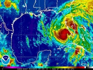
"Satellite imagery has shown an increase in the area of cold cloud tops near the center of Isaac," said Senior Hurricane Specialist Dan Brown in a forecast discussion message. "However, there has not been any significant change in organization in radar data from Key West this evening."
Brown said the storm still is expected to intensify, because of the warm water it will traverse in the Gulf, and an upper air pattern favoring strengthening.
"However, the lack of an inner core and a large wind field could continue to be impeding factors for significant strengthening in the short term," he said.
The storm remains large, with tropical storm-force winds extending out more than 200 miles.
Isaac has continued to slow, and now is moving at 14 mph to the west northwest, with a northwest turn and even slower movement expected during the next two days. At 10 p.m., it was 510 miles from the mouth of the Mississippi River.
Brown said computer models continue to show a wide spread for their predictions of landfall, ranging from the Texas-Louisiana border on the west to the Alabama-Florida border on the east, which means there remains great uncertainty about the final track forecast.
"Throughout the period, it is important not to focus on the exact forecast track due to forecast uncertainties and the fact that significant hazards extend well away from the center," he said.
Category: Louisiana
|

